Saturday, June 7, 2008
whirlwind memorial day yosemite trip part 2 of 2
When I planned this day trip to Yosemite at the end of our conference-going time in San Francisco, I failed to notice that Sunday, May 25th was Memorial Day. I knew that the high price of gas would deter some people from making the trek to the park, but that in reality it would still be pretty insane. However, since the primary reason for going to Yosemite this time was to go to Mariposa Grove, I figured there would be some time that was relatively people-free. That was true. But as soon as we left the Grove and made the drive into the Valley, it got a little crazy.
Poor Michelle, who had to deal with me changing the plans all along the way. First, I figured we would potentially have time to do the walk up to the base of Bridalveil Falls and the walk up to the base of Lower Yosemite Falls. That was the initial plan—it was going to be a driving tour of the valley with two major stops. But that didn't materialize.
We were basically the epitome of Muir's "sticks of condensed filth," the travelers who descend on the mountains but are not of the mountains. I felt bad about that.
The drive from Mariposa Grove to Yosemite Valley is a little over thirty miles. Along the way you pass Wawona, which is a good place to take a potty break and stock up on water and food. We tried to do that, but the parking lot was full and we were on a tight schedule, so we pushed ahead. The next stop would be Tunnel View because Glacier Point Road was closed. It had been open, but it was very foggy and chilly and I don't doubt for a moment that closing Glacier Point had more to do with the tons of people who were in the park than the actual road conditions. I can't imagine the hordes of cars going down to the point, in the fog. I almost ran us off a cliff last time I was there, and it was sunny and bright and no one else was on the road. Good call, National Park Service.
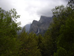 When we hit Tunnel View, I was surprised to see the parking lot all closed off due to construction. This was going to make the Tunnel View photo pretty difficult to get. But there were a bazillion cars parked on the side of the road, and we became one of them. I managed to get decent shots of Bridalveil and El Capitan—but note a few things: it was crazy foggy, as evidenced by the fact that at 1 o'clock in the afternoon you can't even see Half Dome, and I'm standing behind and below a bunch of trees.
 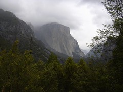 Still, it's difficult to take a really bad picture in Yosemite. Seriously.
We started the loop drive, and I'm thinking to myself that there's going to be no way in hell any of the lots will have spaces in them, so the walks up to the bottom of Bridalveil and Lower Yosemite Falls are going to be out. No worries, I said, as there are plenty of stopping points for picture-taking—Ahwahnee Meadow, El Capitan Meadow, etc. True, except for the insane amount of people paying no attention to rules of the road or parking.
In brief, we didn't stop. Michelle has a bunch of photos of the wonders of Yosemite Valley as taken out of the car window. For my part, I was having an existential crisis the entire time—how could I do Yosemite that way when I work on Muir?!? I was in such a state that I totally screwed up (partially because of a construction-obscured sign) the route out of the valley. I intended to go out the top route (120 to Manteca) but ended up going the middle route (140 to Merced). Let's just say that if we had done the Bridalveil and Lower Yosemite Falls walks, and I screwed up the route out of the park, we would not have landed in Spokane at 10pm as we did, and arrived at our respective houses at midnight.
But I do love Yosemite.
Poor Michelle, who had to deal with me changing the plans all along the way. First, I figured we would potentially have time to do the walk up to the base of Bridalveil Falls and the walk up to the base of Lower Yosemite Falls. That was the initial plan—it was going to be a driving tour of the valley with two major stops. But that didn't materialize.
We were basically the epitome of Muir's "sticks of condensed filth," the travelers who descend on the mountains but are not of the mountains. I felt bad about that.
The drive from Mariposa Grove to Yosemite Valley is a little over thirty miles. Along the way you pass Wawona, which is a good place to take a potty break and stock up on water and food. We tried to do that, but the parking lot was full and we were on a tight schedule, so we pushed ahead. The next stop would be Tunnel View because Glacier Point Road was closed. It had been open, but it was very foggy and chilly and I don't doubt for a moment that closing Glacier Point had more to do with the tons of people who were in the park than the actual road conditions. I can't imagine the hordes of cars going down to the point, in the fog. I almost ran us off a cliff last time I was there, and it was sunny and bright and no one else was on the road. Good call, National Park Service.
When we hit Tunnel View, I was surprised to see the parking lot all closed off due to construction. This was going to make the Tunnel View photo pretty difficult to get. But there were a bazillion cars parked on the side of the road, and we became one of them. I managed to get decent shots of Bridalveil and El Capitan—but note a few things: it was crazy foggy, as evidenced by the fact that at 1 o'clock in the afternoon you can't even see Half Dome, and I'm standing behind and below a bunch of trees. Still, it's difficult to take a really bad picture in Yosemite. Seriously. We started the loop drive, and I'm thinking to myself that there's going to be no way in hell any of the lots will have spaces in them, so the walks up to the bottom of Bridalveil and Lower Yosemite Falls are going to be out. No worries, I said, as there are plenty of stopping points for picture-taking—Ahwahnee Meadow, El Capitan Meadow, etc. True, except for the insane amount of people paying no attention to rules of the road or parking.
In brief, we didn't stop. Michelle has a bunch of photos of the wonders of Yosemite Valley as taken out of the car window. For my part, I was having an existential crisis the entire time—how could I do Yosemite that way when I work on Muir?!? I was in such a state that I totally screwed up (partially because of a construction-obscured sign) the route out of the valley. I intended to go out the top route (120 to Manteca) but ended up going the middle route (140 to Merced). Let's just say that if we had done the Bridalveil and Lower Yosemite Falls walks, and I screwed up the route out of the park, we would not have landed in Spokane at 10pm as we did, and arrived at our respective houses at midnight.
But I do love Yosemite.
Labels: outdoorsy